Published: 27 Apr 2022
The risk to human life through infrastructure failures is one of the biggest challenges that construction and surveying businesses face every day. Even the smallest movements of structures can cause long term complications. Therefore, it is absolutely critical that they are monitored and kept to the highest safety standards. One of our members of 10 years, Survey Solutions, is one of the UK’s largest engineering surveying companies, specialising in land surveying, building surveying, underground surveying, site engineering and monitoring. Founded in 1997 and initially a subsidiary of TA Millard, the company moved to become an independent business following a management buy-out in 2004.
Survey Solutions has extensive experience of carrying out geomatic surveys, across a range of sectors and for all sizes of project, harnessing the latest survey technology to deliver data quickly, in detail and in different formats.
Survey Solutions has used Leica Geosystems equipment for many years, including the use of a Leica TS16 Total Station on site.
Mitigating the risk to human life
Survey Solutions was contracted to conduct a monitoring project of a rail station building and platform, where structural movement had been occurring throughout the site. The remote monitoring data is being used to minimize risk associated with the movement of critical infrastructure, with the final decision on the demolition and rebuilding of the platform also being made based upon the results of the project.
The project is of critical importance as the movement of the structure has already resulted in some changes having to be made to daily operations, including limiting the size of trains that can stop at the station, reducing them from 12 carriages to just 6, due to the potential danger.
The project was scheduled to last for 40 weeks and used the latest technology platforms of Leica Geosystems. This created tailored reporting using simple plug and play solutions to provide the structural health monitoring, particularly displacements in singular prisms to map station movement.
Due to the critical importance of the project, a high-end solution was required. Survey Solutions researched several suppliers, and ultimately it was decided that the solutions from Leica Geosystems were most suited to the project, in particular their ability to validate automatically the TPS location during the measurement array readings to enable true displacements.
Products & Implementation
The package selected by Survey Solutions combined the very latest in Total Stations, Software and monitoring communications.
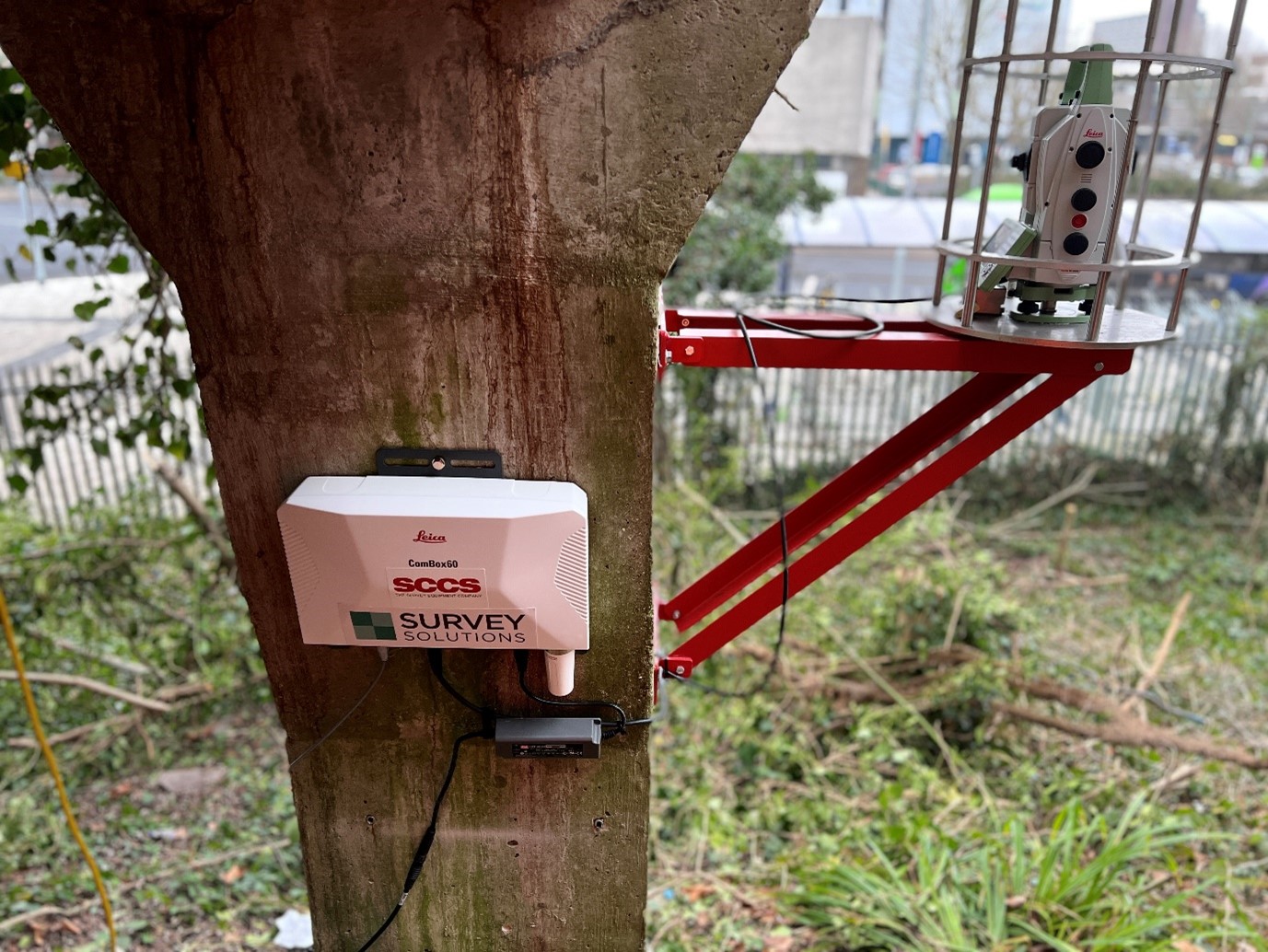
The Leica Nova MS60 was selected to enable Survey Solutions to perform all surveying tasks with one instrument, bringing sensor fusion to the next level by combining highest-end total station capabilities, 3D laser scanning and digital imaging. The MS60 was mounted within a security cage to protect against vandalism and theft. It was controlled remotely to monitor the positions of 20 L-Bar Prisms mounted at strategic points throughout the site.
Remote monitoring was a key factor in the selection of solutions from Leica Geosystems, with limited access available to the station site during operational hours. To overcome this problem, Survey Solutions installed the Leica ComBox60, the key to the complete remote monitoring control solution. Designed with simplicity in mind, the team from Survey Solutions mounted the ComBox60 on site before connecting the MS60. This solution allowed the team to operate the MS60 remotely without the requirement for site visits, increasing efficiency and simplifying the geodetic monitoring sensor operation in the field.
Leica GeoMoS software allowed seamless connection, automated sensor control and instant data storage with powerful deformation analysis to Survey Solutions. GeoMoS Monitor ensured 24/7 operation of the measurement cycle and stored all the captured information in a database with no data gaps.
The first sets of data were captured manually through the GeoMoS interface, after the installation of prisms, MS60 and ComBox60. This data was then used for initial points that would be monitored throughout the course of the 40-week project to provide deliverable displacement data. Multiple sets of data were captured at different times of the day to assess any deformation caused by the changing environmental and structural condition.
Full training was provided by the team of experts from SCCS, allowing Survey Solutions staff to confidently use the products.
Benefits
The solution was delivered and installed in time to begin the project on a tight schedule, with support provided to the Survey Solutions teams as required. The simplicity of setup, ease of reporting and dynamic software capabilities ensured that all expectations of customer and asset owner were met.
The combination of the MS60 and ComBox60 enabled Survey Solutions to control the project remotely, reducing the need for the team to travel to the site to conduct the monitoring activity. This method of remote automated monitoring not only increased efficiency by reducing time spent on site visits, but also provided significant costs savings and minimised the impact on the environment through a reduced carbon footprint.
“We have used Leica solutions for many years due to their quality, plus the support we receive from Leica is second to none. The reporting capabilities and simplicity of the solution make it the ideal setup for this project. We are already planning another MS60 project with Highways England using patch scanning. We could not be more pleased with the results and the support we have received from Leica and SCCS.”
David Mainwaring | Director – Survey Solutions